
After having a solid race at USARA Nationals, Jeff, David, and I joined up with our trusty fourth Doug to head to the Checkpoint Tracker National Championships. We were all feeling pretty good with recovery from USARA (and Doug from a friend's wedding) so we were excited to see how the race shook out. We left on Wednesday night and drove as fas as Nashville before crashing. Then on Thursday it was a relaxed morning, complete with my first-ever trip to Waffle House, and a short drive over to Knoxville for pre-race activities. It was pretty cool to see this city from an AR perspective. I'd actually raced here once before in 2012, but that was for a triathlon and we stayed on a marked course the whole time.
 |
| Yes we ate all of that! |
 |
| WEDALI 1 getting their map! http://instagram.com/p/fTpq1WvsiB/ |
- Section A: no maps yet, 9 CPs rogaine-style, any mode, plus shooting challenge and 2-3 extra orienteering points (rogaine-style means we can go to the CPs in any order)
- Section B: no maps yet, 11 CPs rogaine-style, must bike to BA and then collect B1-B9 on foot, B10 and B11 any time, any mode
- Section C: starts with 27-mile paved road ride with 1 CP. Then a 28-mile paddle with 2 paddle CPs and 6 intermediate trekking CPs. Then 12 CPs rogaine-style of biking with two rappels and 4-6 extra orienteering points.
We grab our map and custom plotter and get to work for a few minutes before boarding busses. Doug and I plot the remainder of the course on the bus, trying to not mess up the map, while David drinks too much water. We have some time to route plan before getting off the bus, but it's really hard since the map scale is weird - somewhere between 1:29k and 1:36k. Plus the contour interval is 100 feet. I've never been on a map this huge, and it's going to be really hard to identify finer features. But we've raced on weird maps before, so we will figure something out. We make friends with the team sitting in front of us, Fortis Mons, and they are locals so they share some information about the vegetation (not that thorny) and terrain (steep). They also share an empty Gatorade bottle when David has a bathroom emergency - he fills the whole 32 ounce bottle in one go, on a bumpy bus! I knew I had talented teammates! The busses let us out at WindRock ATV park, and we have an hour to mess with our bikes and maps. We figure out a logical route for Section A and decide to go after it on bikes. We wish all of our friends good luck in the race, and pretty soon we're off!
Section A - Bike - 1000-1600
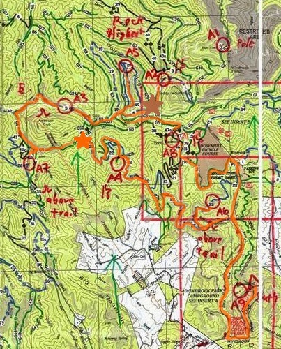
We take off with the majority of the field on bikes and very quickly, the field splits. Most teams take a right turn onto a gravel connector road, while we opt for the longer, paved around-route that eventually brings us back north. The paved descent is very steep and twisty, and we're riding in a loose pack with a few other teams. I misjudge one of the curves and, not wanting to over-correct into someone else's line, I find myself hurtling into the gravel ditch. Um....this is bad. I brake as much as I can and by the time I hit the ditch I'm at a more controlled speed, and it looks pretty rideable so...I ride it out. Doug's seen this all happening so as I'm getting back up to speed I see him waiting for me. "It's all good!" I shout, embarrassed at my horrible bike handling, and the two of us take off to catch Jeff and David. We ride with a few other teams but by the time we turn off of the pavement we're by ourselves. We attack A6 as an out-n-back and are introduced to the WindRock trails. They are HILLY: short, steep, grunty efforts that will grind our quads to pulp in no time, but not especially technical. So we spin each one up and pretty soon we are able to grab A6 right as WEDALI 2 is rolling in. Hi buddies! We continue on trail 22 to A4, and then we hit our first decision point (shown at the orange star on the map). We picked A7 as a good skip (jettison!!!) before the race, and these trails are already taking longer than we thought, so we have a quick team conference to figure out what to do. I am determined not to skip CPs, and I express this to the team. Jeff looks me in the eye and says he's heartbroken too, but we have to look at this logically. A7 is a logical skip. I understand and reluctantly agree. We take off towards A3, except we have a really hard time finding the trail junction we need. We see WEDALI 1 riding around here too and that makes us more confused. We mess around with the map some more, decide that we actually should get A7, so we chase hard back to the west. A7 has an easy attackpoint and we pick it up with a short trek, and I am secretly pleased we haven't skipped after all. Then we ride around to A3, through several teams milling about, as David quietly shows Jeff the correct reentrant to go punch. The other teams catch wind of our success and we aren't as sneaky as we thought getting out of there. But leaving A3, we spot a parallel feature with several bikes incorrectly dropped at it and we cheer ourselves on.
Then it's up to A5 which requires careful nav through a spaghetti bowl of trail junctions. We are able to follow them for the most part, but it's a lot of stop-and-go riding which isn't fast. To top things off, the connector trail we want to take to the top of the ridge is extremely overgrown and not signed. We miss it on the first try, and on the second one discover the impossibly steep, weedy trail. This is a serious hike-a-bike, but we've already spent time looking for this trail so we might as well take it now. We all grunt uphill for a couple hundred feed and finally pop out onto the high trail. From there we can ride until the north end of the ridge where we get off and have more climbing to do on foot for the punch. The flag is missing here but there is a ribbon with a code so we write it down and continue. We do this with WEDALI 2 as well and it's fun to be racing with friends. It's a scary downhill ride back to trail 4 but I channel some Sona bike mojo ("the bike wants to stay up") and ride as much as I possibly can.
 |
| Just add some dirt to this water. |
 |
| Team Tecnu's Kyle zooming around. What a mud splasher. |
We ride back to TA about 3pm, preparing to split up to tackle the shooting challenge and the optional CPs. I do better in the heat than my teammates so we decide to send me and David after the optional CPs and Jeff and Doug will shoot. As we're riding up to the pavilion, we hear a HISSSSSSS and Stan's starts shooting everywhere from Jeff's rear tire. Crap! Except, it's not really that horrible since he and Doug can change it after they're done with the short shooting challenge. It takes me and David FOREVER to get out of TA - first we can't find the map for the 2 optional CPs and run twice between the volunteers and the course designer to locate it. Then we forget the passport so we run back to Jeff to get it. Then we decide that these points are better attacked on bikes so we run to our bikes but get on them without changing back into bike shoes. We are a mess! But after all of that frenzy, we ride out of TA just behind Biz and Mari from WEDALI 1 so we are still in an okay spot. We are all keeping the same pace on bikes (even with me and David in our trekking shoes) so we sort-of-unspokenly-mutually agree to attack these together. The first point in the pond is easy. We ride right to it and Mari and I wade through the brackish water for the punch while the boys sun themselves on the bank. (SIDE NOTE: Mari is veteran expedition racer from Dart-nuun who was guest racing with WEDALI. I was stoked just to ride with her for a little bit. She's awesome!!) The second point is difficult and we all get lost in the maze of unmapped (and steep!) trails. We do a complete loop through the trails and then finally find the flag on the second pass. Now we just ride back to TA where Jeff and Doug have successfully changed the flat and have had plenty of time to prepare for Section B. We know Tecnu left at least 30 minutes ago with all points, and WEDALI 1 is leaving right in front of us with all of the points as well. We have skipped one CP but are in good shape.
Section B - Bike/Trek - 1600-midnight
 |
| Our route for Section B. |
We finally roll into BA and are met by my favorite volunteer, Chris!!! Chris is part of the WEDALI crew and I first met her at last year's CPT Nationals when I raced with Andrei. She was super great to us in TA at that race, and I am so excited to see her smiling face at this point in the race because we're in a little bit of a low spot. We know we won't be even close to clearing the course based on how many B points we anticipate dropping. But she encourages us on anyway (and sweetly refuses to divulge any info on WEDALI - cutest ever!) and we run out of BA on a mission - we have 2.5 hours to get as many CPs as possible before returning to BA for our self-imposed deadline of 9.30pm.
 |
| Our trek loop starting at BA. |
It takes a team effort to find B3 because the reentrants are more detailed than the map shows, but eventually Doug spots the flag and we drop back onto the 12 trail for some running. Time check: 45 minutes gone, but we've got 2 CPs! Go Alpine Shop! We run for awhile on the 12 trail which crosses the creek several times. For the first few crossings we all pick our way over rocks and keep our feet dry (dry-ish for me, mine were soaked when we punched AB). Then we climb the 10 trail to attack B4 off of the bend. The veg is nasty, very thick and thorny, but we push through since it should only be a few hundred meters from the trail. The contours show a big reentrant so we just bushwhack north, expecting to fall into the feature and then find the flag upstream just a bit. Except, the big reentrant never materializes and the veg is slowing us down tremendously. We all gather around the map, and agree to press onward for 5 more minutes. If nothing changes, we'll bail on the B4 and head back to BA. No arguing or what-ifs. 5 minutes. Go.
I set my watch and 5 minutes later...nothing, except a lot more thorns. This hillside is just awful! We can't afford to waste any more time so we bail west/downhill back to the 12 trail. Once we get there, we start running back towards BA. We have an hour to get back to meet our self-imposed deadline, and David thinks we can hit B2 on the way to wrangle 1 more point out of this section. So we make a Leroy onto the 9 trail, then follow the creeks up to the CP. It's waaayyyyyy up there, and this takes more time than we thought, so by the time we're headed back to BA we're an hour late. We feel sort of sheepish, like kids missing their curfew, but that feeling is erased when we see Chris again and she tells us that WEDALI 1 and Tecnu are still in the woods. This is really, really good news for us. Remember the pre-race meeting when the course designer told everyone that the course was impossible to clear? Well, now we know that both WEDALI and Tecnu are trying to do the impossible, and they've left the door open a crack for Alpine Shop to race our smartest. The crack's not that big since we know Tecnu is stacked with frighteningly fast athletes, and WEDALI did the impossible last year at CPT Nats - clearing the course when Ronny said it couldn't be done. But, that tiny sliver of hope is still there, and we are going to chase it down hard.
 |
| http://www.flickr.com/photos/transluminate/1057195740/ This photo is looking at Knoxville from the south, and we were looking at it from the north, but same idea. |
Section C - Bike on Roads - midnight-0300
 |
| The biking section, starting in top left corner and continuing south to the paddle put-in. 1:50k!!!! Sorry our markers bled a little bit, this map got wet in the boats. |
We are greeted by two really nice volunteers who tell us where to put our bikes, and I get to work assembling paddles. The boys get PFDs and glowsticks sorted as we all make sure we have enough caffeinated items to see us through the witching hours. Still no sign of WEDALI or Tecnu and that's the way we like it. David hands me the paddle map, and we shove off into the darkness of the Tennessee River!
Section C - Paddle - 0300-1100
 |
| First 20ish miles of the paddle. 1:30k scale. |
 |
| http://people.tribe.net/sam_da_pearl/photos/2f8100e2-6c18-4bc8-9236-b9bdd7bff551 |
Then, out of the mist, we see a silo. What the what? It's just so surreal, a huge silo in the middle of the river, that we couldn't see 10 meters ago. And now we're practically touching it. But wait! What's this? David finds it on the map! We are exactly where he thought we were. It's all good! Let's keep paddling! But not before Doug and I pee.
We keep paddling and the fog gradually begins to lift. This is a really good thing, because we're getting close to our first paddle CP, C1. It's supposed to be on the north shore of the river and, after some careful inspection, our headlamps ping the tiny strip of reflective tape on the punch. Relief! We get back into the main channel and continue upstream.
We are seriously into the witching hours now, and the stress of the fog-out has been released a little bit. Our eyes are getting really heavy. I find that talking/singing/whistling works for a little bit, but what works even better are BuzzBites and jerky. Yum. Munching on these two things helps me keep fighting the sleep monsters (after the race, Mari from WEDALI was incredulous that we even thought about getting tired in just a 30hr race. what a badass). Doug is not as successful in his sleep monster battle. After a few close calls with the river, he asks for a nap and a tow. Jeff and I use the boats' pre-attached ropes to rig up a tow and we keep the team moving while Doug gets some beauty sleep. Ha! Jokes on him though, because when he wakes up he's soaking wet and cold. But, he's awake in time for us to punch C2, which we do in a half-fog around 2 other boats. There is a pre-dawn hush on the river and apart from making sure they don't need anything, we don't chat. Imagine that...Alpine Shop, not chatting.
Sunrise finally comes to us and it is welcome. The temperature has been perfect for me - I'm in full rain gear and there has been just enough chill in the air to keep me awake, but not enough to shiver. But I'm ready to be warm again, and the sunrise helps that. It's beautiful as the rays illuminate the misty, wooded bluffs. I feel like I'm in Middle Earth or something. Nope, just Knoxville! With the sun up, our 4pm finish cutoff is now a looming reality. We have so much ground left to cover and even with 9 hours left, we're stressing. David keeps his eye on the map and we debate if we should even go to IC King, where three CPs are waiting for us on foot. We know one of the CPs is really close to the take-out, and another could be a 250m swim away, but unfortunately the take-out is a good kilometer away from the main channel of the river. With our slow pace through the fog, we can't afford an extra 2k paddling plus running and swimming for only 2 CPs. So we paddle past IC King and mourn the skipping of another 3 CPs.
 |
| Finally, our 1:24k map!!! Rejoice!!! |
Enough complaining about the paddle. Sorry! Did I mention that my personal paddle is awesome? She's an Epic Small Mid Wing 4pc carbon paddle and we call her the princess paddle since she travels in her own personal case, separate from the "common" paddles used by the rest of the team. Well, the boys use really nice paddles too, they just have lost their cases. I'm far from being a good paddler but the wing blade really helps me feel the water and keep my stroke connected. And that's really all I know about paddling. Unsolicited commercial over.
We are paddling along, finally in full sun, and Jeff and I start to see houses. Big ones. And people. Skinny ones (cross country runners at a meet). There are some bluffs to our right that look cave-ish and we think surely...SURELY...C7 must be just up ahead and from there we're almost to the take-out. David and Doug are right behind so Jeff asks "Hey David, how are we doing? Almost there?" David looks down into the bottom of the boat and replies "Well, we're gonna go right some more, then left, then straight-ish, then a big right turn....and then I turn the map over."
The silence is deafening. I don't even need to turn around to see the look of "are you kidding me" on Jeff's face. David's got this crazy "this is horrible in a sort of funny way" grin on his face, and Doug is seriously ready to stop paddling. I tend towards David's emotion...this is turning into a much longer paddle than anyone bargained for, and it IS horrible, but there are no people I'd rather suffer with than these guys. We each take our 30 second pity party, and then regroup and refocus on getting ourselves to the cave. We do some more towing since Jeff and I are feeling good, and then finally we spot our reentrant and tiny tiny beach for C7.
Section C - Cave and Short Paddle - 1100-1200
We are all so happy to do a little trekking at C7. We beach the boats, and then have to re-anchor them when a speedboat wake jostles everything loose. At least that happened while we could still see the boats! We run over to C7 and find a happy volunteer waiting for us. She gives us the cave instructions, telling us that we can split up to get the cave and C8 and C9 at the same time. We're a little confused since we thought there were extra CPs for the cave, but that's incorrect. Doug and I tackle the cave while Jeff and David sprint off for a quick 1k o-loop.
The cave is skinny and slippery and all of a sudden we have the company of another team! The six of us work together to find and access the hidden jack-o-lanterns full of candy. I can't remember their team name but I think the woman who figured out how to get to the candy was Sue. So, thanks Sue, for helping us all out! Doug and I have some time once we emerge from the darkness, so we chat with the volunteer. Whenever I have the spare time to chat with a volunteer during a race, I preface it by saying "I'm going to ask you a ton of questions and if you don't want to answer any of them, or if I get annoying to you, you can tell me to stop and it's okay." This volunteer laughs and introduces herself as Karina, the course designer's sister. Awesome! So I pump her for information on Tecnu and WEDALI. She doesn't have any news on our Minnesotan friends, but she tells us that Tecnu didn't put-in until 9.30am. Doug and I look at each other, stunned. We know Tecnu are really good paddlers but 6.5 hours is cutting things awfully close. We hope they won't have to deal with the fog that we just paddled through. We chat about the rest of the race with Karina, and then Jeff and David come storming back for the punch. Awesome! We rush back down to our boats and as we're getting back in the river, we share the Tecnu news. This really lights a fire in our bellies. We paddle hard for the remaining 2k, all the while doing CP math and calculating our total (21 in the bag so far, with time to get more) vs. Tecnu's total (24 if they cleared A and B plus the two easy paddle points on C). Things are looking good on that front, but we don't have any news on WEDALI which means they probably put-in before Tecnu and are hunting us down right now. Yikes! We see the take-out and...HEAR the take-out. Dave, Erl, and Chris from WEDALI are there, some volunteers are there, I think Swiftwick is there, it is a bunch of people and they are cheering us on like crazy. It's so amazing to come off the water to the encouragement of our friends. We rip apart our paddles, throw them in the bag (sorry princess!), and then run with everything to Outdoor Knoxville, where our bin and bikes are waiting for us. There, we hurriedly transition and I take water bottle duty. I run them all down to the Outdoor Knoxville building, intending to go inside and use the bathroom faucet (and the bathroom myself). It's locked. What? I try another door. Locked too. I race up the outdoor stairs to a third door. No dice. I NEED to fill these water bottles...and there is a huge landscaping fountain staring me in the face. We have bleach at the bin. Done. But I still need to pee. Yes. I peed in the landscaping at Outdoor Knoxville. Sorry. I run back to my teammates with full bottles and an empty bladder, tell Jeff that we need to treat them, and finish up with the rest of my transition.
Section C - The Cornucopia of CPs - 1200-1538
 |
| Left from Outdoor Knoxville (west side of map) and went CCW. |
 |
| Another racer rappels into the water. |
The boys come sprinting back to C10/11 with three successsful punches on their extra map. We joyously hop back on our bikes and ride off to get C12 which is just north of us. Jeff and David actually spotted it while on their extra trekking loop, so they lead us directly to the punch. Then, we have a team meeting. We've got 27 CPs so far, and its about 2:15. We want to be at Outdoor Knoxville 3.30pm to have time for the final trek. Should we go for C13? We can do 11k in an hour no problem! But the boys are worried that we wouldn't get the punch at C13 if we don't do the rappel, and that could take more than an hour. And we probably wouldn't have time for that extra trekking loop. So we look for a stand-alone CP and decide to go get C21, which is a similar 11km ride. Let's do it!
The ride to C21 is tense. We are back in a very urban environment and not all of the streetnames are shown on the map, nor are all of the streets signed in the first place. We hunt and peck for the right intersections and are momentarily flustered when we cross an major 4-lane road that isn't on the map. Plus every other streetname is some variation of Siever...Siever Rd. Sieverville Rd. Old Sieverville Rd. Sieverville Pike. Old Sieverville Siever Pike Rd Siever Rd Pike. WHO IS SIEVER!?!?! But David's feeling good so we follow. We're almost make it to our trail/road junction when we get sidetracked on a gravel road/driveway. Team conference...where are we on the map? Which map are we using? We have two, our 1:24k USGS and a race-provided park map of the South Loop. I happen to look at the South Loop map and spot the curlicue gravel road we accidentally turned on. We're not that far from the CP. We descend back down to the pavement, finally find the trail, and are absolutely delighted at the singletrack that awaits us. It's only a few hundred meters but wow! Awesome stuff! We are really sad we didn't get to ride more of it. Jeff punches C21 under the bridge and now we have to race back to Outdoor Knoxville for instructions on the final trek.

The ride back to Outdoor Knoxville is tense but David does a great job picking out the streets that we need. We coast back into the parking lot TA and receive verbal instructions for the final trek from the same two volunteers who were at the paddle put-in at 3am this morning. Dedication! With our end-of-race-brains, we are sort of confused about the instructions (follow the green and pink survey tape) but we find the course designer in the parking lot too and he confirms "Just follow the green and pink survey tape". It's really not that hard but we are mentally drained. So we follow the tape, and it turns us into a huge box culvert full of rushing water. An underground creek! Cool! We splash through the tunnel, and I enjoy the quiet time to collect myself before being thrust into the chaos of a finish line. We've run a really good race. We've kept each other awake, hydrated, eating, and moving well for 29 and a half hours. We all still like each other. We've made what we think are good decisions. We have one final punch in the culvert before running through downtown to Krutch Park and the finishing pop-up tent. Jeff turns in our passport, we are handed a bottle of water, and we are done.
POST-RACE
 |
| Spoiler alert: we won. Even the Mayor of Knoxville knows! |
We had a lot of mixed emotions following this race. I won't go into all of them because it honestly took us the entire 9hr drive from Knoxville to St. Louis to really believe that we won, and be proud of ourselves for it. The rogaine race format had a lot of people complaining, and the Checkpoint Tracker logistics of the entire weekend just added fuel to the fire. At the awards presentation, we didn't feel like we had just won a championship race, nationals or otherwise. But after discussing it at length within our team, and receiving several notes of encouragement and congratulations from racers across the country, we have come full circle. Every team out there had the same information, for better or for worse. We all knew about the last 1:24k USGS map and the 23-25 CPs it contained before the race even started, and the several hours of biking and paddling it would take to get there from the undisclosed start location. Once we got on the WindRock map, and realized how slow we were on it, we made the decision to hustle to the last map and salvage what we could. Those decisions, combined with working together for 29.5 hours, earned us the win. We are Alpine Shop, your 2013 Checkpoint Tracker National Champions.
WANT MORE?
Team Tecnu: https://www.facebook.com/permalink.php?story_fbid=568871593148222&id=162254323809953
Gearjunkie/WEDALI: http://gearjunkie.com/checkpoint-tracker-championship-2013
Richmond ASR - Raging Burritos: https://www.facebook.com/permalink.php?story_fbid=693571517322518&id=133544796658529
Pin It
Wow!! If I had more than a few days off work I would have read it all!! ;)) Emily nice work and great write up! That was loooooooooonnggg.......
ReplyDeletegood thing you have superior reading endurance. i commend you!
DeleteAwesome race report. I'm glad you all are basking in the warmth of a championship well deserved. That is as it should be.
ReplyDeleteAlso, thank you for including a picture of us in both of your last two race reports. I feel like my celebrity is at an exciting all-time high right now.
Mari Chandler, what a badass, right? Kyle Peter, what a mud splasher! Your paddle, what a princess.
Thanks, Tom. We are basking. Although I feel I should be thanking YOU for elevating MY blog celebrity by having your picture posted. Truly brings is up several notches.
DeleteSara Dallman and Steph and Ben from Flying Squirrel lasted through the whole thing (AND we're racing tomorrow morning!). We just couldn't stop reading. Thanks for sharing your experience with us. We love you guys and we're so tickled for your big win! (we're singing "We are the Champions" in your honor right now)
ReplyDeleteYeah Flying Squirrels! Thanks for enduring the entire report! I think I can hear your singing from STL!
DeleteCongrats on a well executed race! Paddling in the fog sounds nerve racking.
ReplyDeleteThank you! yes...it was very stressful!
DeleteDang...this is so unfair...I stayed up late reading this as soon as it posted, and then Blogger ate my comment! :) I replay that Jeff Sona quote literally every time I ride down anything I consider a scary downhill. And we've got a picture of us ahead of Tecnu, too...of course, that was from LBL when they lost their passport, went back for it, and still won the race!
ReplyDeleteAnyway, SO stoked for you guys and your win! Smart strategy and tough racing! Great job Alpine Shop!
aaahahaha i just HAD to go look up that photo, and i was not disappointed!!! http://team-virtus.com/2012/04/05/a-constant-struggle-the-lbl-challenge-adventure-race-report-part-2/
Delete